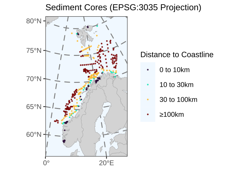
| Distance | # Sediment Cores |
|---|---|
| 0 to 10km | 70 |
| 10 to 30km | 26 |
| 30 to 100km | 122 |
| ≥100km | 165 |
Distance Calculation
Distance calculation to the nearest Norwegian coastline from core locations
As the initial data analysis will be performed on the Mareano cores/samples located within Norwegian fjords and surrounding areas near the Norwegian coastline, the distances to the nearest coastline were calculated.
The distance data is available in the dist_to_coast column of the Core table.
Sediment Core Locations
Distance Calculation
Count of Four Groups
The table summarises how many observations fall into each of the four groups, broken down by distance categories.
Methods
Coastline data were derived from the Global Self-consistent, Hierarchical, High-resolution Geography (GSHHG) database. High-resolution shoreline polygons were extracted for the region covering the Norwegian mainland and the Svalbard archipelago. The coastline geometry was cleaned and filtered to ensure topological validity before calculation.
To ensure accurate measurements at high latitudes, where standard global projections (like Mercator) distort distances, all spatial data were projected to the ETRS89-extended Lambert Azimuthal Equal Area projection (EPSG:3035). This Coordinate Reference System is the standard for pan-European statistical mapping and minimizes distortion across the region. The shortest Euclidean distance from each sampling (core) site to the nearest Norwegian coastline geometry was then calculated in meters.
The calculation was performed using the sf library in R.